Mt. Willard is a very easy up and down with an amazing view at the summit. The best time to hike this mountain is during the fall to capture the fall foliage.
Mt. Willard Trail is located in the Crawford Notch State Park. The trailhead is located in the same location as that of Avalon Trail, but instead of going straight, you would take a slight left onto Mt. Willard Trail. Since, we hiked Mt. Tom via Avalon Trail it was very easy to locate.
The trailhead for this hike starts at the Crawford Depot/Visitor Center on Rt. 302, just before the AMC Highland Center. Anytime we hike in this area, we stop off at the Highland Center to get trail reports and if needed to sign in and out of the hiker log.
Here is the trail from the north view. Our total trip was 4.1 miles from our location at the highland center to the summit and back.
4D Map TrailElevation
The trail condition for us was packed snow and easy water crossings. If you are hiking this trail during the winter, I suggest running into the Highland Center and speak with the AMC folks at the desk. Depending on what the weather was before your hike day, water crossings can be hard to pass or not passable at all. There are a few areas of the trail where you will have to duck under or walk around some broken or snow pushed branches. These areas of ‘obstacles’ are very easy to walk around.
We used our micro-spikes for this climb. It is an easy hike on packed snow, but with a moving toddler on your back its helpful to have some grip to the earth. The climb and descent are very straight forward and rather uneventful.
Here are some images from the trail.
Crawford’s Depot
Trail
Us on the trail
Centennial Pool
Coming down the trail
Here are some few from the summit…
Mt. Webster
Summit Picture
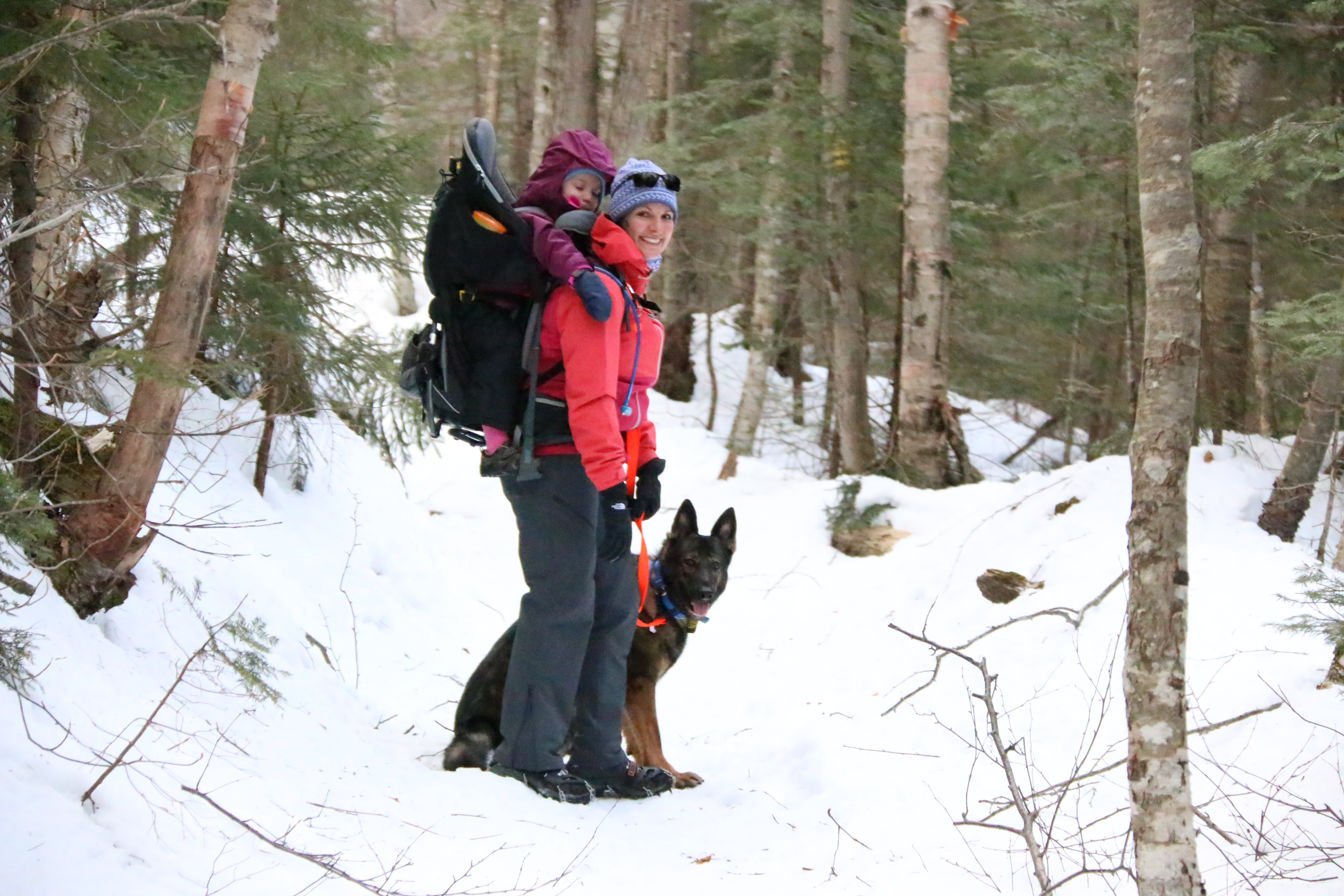
As you can see, we added another family member to our hiking team. This was Abby’s first formal hike and she did very well. It was a little confusing in the beginning since we forgot her gear. The gear is key in helping Abby understand it’s time for ‘work’. She stayed on her lead the whole trip connected to my pack and loved every moment. Our goal is to have Abby completely condition and trained for longer and harder climbs by this spring where she will join us on each hike.
What can I say about this hike? I think one word sums it up, beautiful!
Lonesome Lake is a wonderful location for families or anyone who wants to spend some quality time in the mountains. The views are incredible. Basically, it’s a small slice of heaven in the Franconia Notch State Park. You can find out more about Lonesome Lake, here.
The lake has an AMC Hut about 400 ft from the lake. For more information about the hut, you can find it — here. This is a popular hut during the summer time, so plan ahead.
We planned to stop by this hut for our normal break routine. ie.. water refill, bathroom, snack time, let M out and run around. During, our short visit, I heard the same question asked several times by different hikers. I have heard this question asked at other hut locations. So, I am going to take a moment and answer it. And for anyone that needs this question answered. I am sure the staff is sick of answering it. So, what’s the question, you wonder…..
“How do you guys get the food up here?”
The answer is simple the staff carries it up. There is no special helicopter delivery system, no ATV, no dirt bike and no green men from Mars who beam the food in. It’s that simple, the staff carries it up and cooks it for you. These are the same people, who answer your questions regarding your stay, trail details, clean up after you leave and brings down the trash they created and the trash that you forgot about or purposely left behind.
So, remember to thank them. Even when we are just passing through using the bathroom, siting at the table and refilling our water, we thank them. They are always preparing, planning and answering questions. Yes, they love their job, but a little appreciation goes along way.
And remember it’s not their job to carry down your trash. They carry up all the items to make sure stay at the hut is one of your best stays ever. They carry down the trash, so help them out by carrying down your own trash. We carry all our trash down, which includes M’s dirty diapers. Just do your part, even if it’s just a few tissues.
And please, do not ask this question again… 🙂
Okay, off he soapbox and onto our hike…
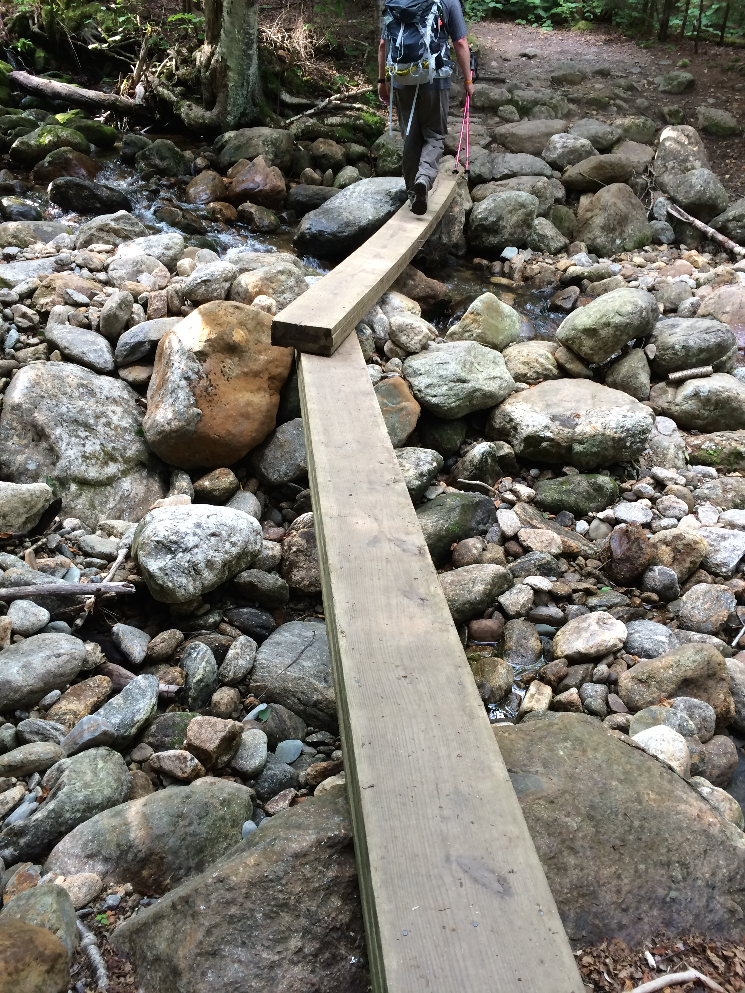
We parked at the Basin and walked the Pemi Trail to the Cascade Brook Trail. If you do not like water crossings this is NOT a hike for you. Your first major water crossing is tough. We ended up back tracking about 250 feet to find a location to cross. Your second major water crossing is at the junction of Basin – Cascade Trail and Cascade Brooke Trail. This bridge was washed out a few years ago and still has not been replaced. In high waters, there is no way to cross this with a child hiking or on your back.
There are other paths you can take to get to Lonesome Lake, such as, Lonesome Lake Trail. Pretty straight forward trail name on the map.
Here are some pictures from getting ready to go and the Basin area…
Ready to go with Miss M looking at Cannon Mt.Mom and M at the BasinThe Basin
The Pemi Trail follows the brook and connects with the Cascade Brook Trail. You will literally walk into this sign.
Pemi Trail & Cascade Brook Trail
Yes, as of 2014 the bridge is still out. And do not get all upset about it. There are only so many volunteers to help rebuild and maintain trails and only so much funding.
Heavy rain, smelting snow and just good ol’ White Mountain weather can cause the water to run high. If you are unsure about crossing water then skip this trail and head up the Lonesome Lake Trail. If you are hiking during the early Spring and don’t want to carry a canoe for about 1.5 miles to Cascade Brook to cross then re-plan your route. All jokes aside, we travelled up and down the Cascade Brook to find the best place to cross. What is easy for a regular hiker with a 5 lb pack is not the same for one with a 42 lb pack with a moving child. It is a bit of a challenge.
Once you are on the Cascade-Brook Trail the climb is very easy. I use “very easy” since we have hiked the Jewel Trail, Webster-Jackson Trail, 19 Brook & 19 Mile Trail, Baldface and many others. The Cascade-Brook Trail is a great beginner trail up to Lonesome Lake minus the water crossing. The climb is gradual and the terrain is very basic. You will deal with some rocks but nothing too strenuous. Even though, it is a basic/easy trail, during or after a good rain, some of the terrain a bit more challenging. So, use a bit of caution.
During our hike up to the crossing… Miss M decided it was time for a nap.
Loving the new chin pad by Deuter… M is happily napping
Here is the junction of the Cascade Brook Trail and the Basin-Cascade Trail. Along with a few other trails.
Junction… Yes and M is napping again…
This water crossing was a bit tricky, not as much, as the one we faced following the Pemi Trail before meeting up with the Cascade Brook Trail. We were about to cross when another hiker coming down the Cascade Brook Trail and gave us a hand. And no, that’s not the ’round of applause’ hand. He took the time to help me and M across the water. He stood in the middle and helped to guide me along to J. We could have done it alone, but this hiker took the time to show us generosity. Not many do, and we give him many thanks.
This crossing is not made for first timers or amateurs hiking with a toddler, one miss step or slip, you and yours will be mid-leg or laying in rapidly moving water and will hit every rock in the immediate area on your way down.
From this crossing, we ran into a group of hikers at another junction. This junction is for the Kinsman Trail or Kinsman Shelter and the Lonesome Lake Hut and Cascade Brook Trail. They were on their way to the Kinsman Pond, which you can access the from the Cascade Brook Trail, just turn left at this junction. We ended up taking some time to help their group decide what path was best for them based on time, water needs and their strength. We used our good old fashion AMC White Mountain Guide Map to give them a better visual of the trails, inclines and locations of huts.
I know shocking we are a high-tech family, but our go to item is a paper map that is secured in a waterproof plastic zip lock bag. In fact, we didn’t just use this map for this one instance, but we pulled it out at the junction point of Hi-Cannon Trail, Kinsman Trail Ridge and Cannon Mountain and Lonesome Lake Hut.
Once, you get to this junction for the Kinsman Trail & Shelter and Lonesome Lake Hut, you have 0.8 miles to Lonesome Lake then another about 500ft to the hut. The 0.8 miles is filled with bog bridge crossings and rocks. The rock trail is basic, but take note of the moss on the rocks. If you do not know what moss looks like it’s the green stuff on the rocks. The moss makes your footing troublesome. Just be wary of the moss. No need to slip and get an injury.
The whole hike up to Lonesome Lake is absolutely worth every view. I mean it, do a 360 and take in it the beauty. Since, we hiked Little Haystack to Mt. Lincoln to Mt. Lafayette to the Greenfield Hut and down the view of the that range was incredible. We took a moment and reminisced about our last summer hike of 2013 before carrying on up to the hut.
At Lonesome Lake on the way to the hutMarker along the way to the hut
View across the lake
Across Lonesome Lake Hut to Franconia Range
We spent some time at the hut. With helping the hikers at the junction and our normal scheduled hut time. We fell behind our time-table by an hour. An hour, is not much, but when facing some serious climbing the added time is very important BUT we cannot skip our rest time. Rest is so important during long hikes. We made the decision to head up to Cannon Mountain and two additional back up plans during our rest at the hut. All the while, M was snacking on your sandwich and talking to whoever or whatever would listen.
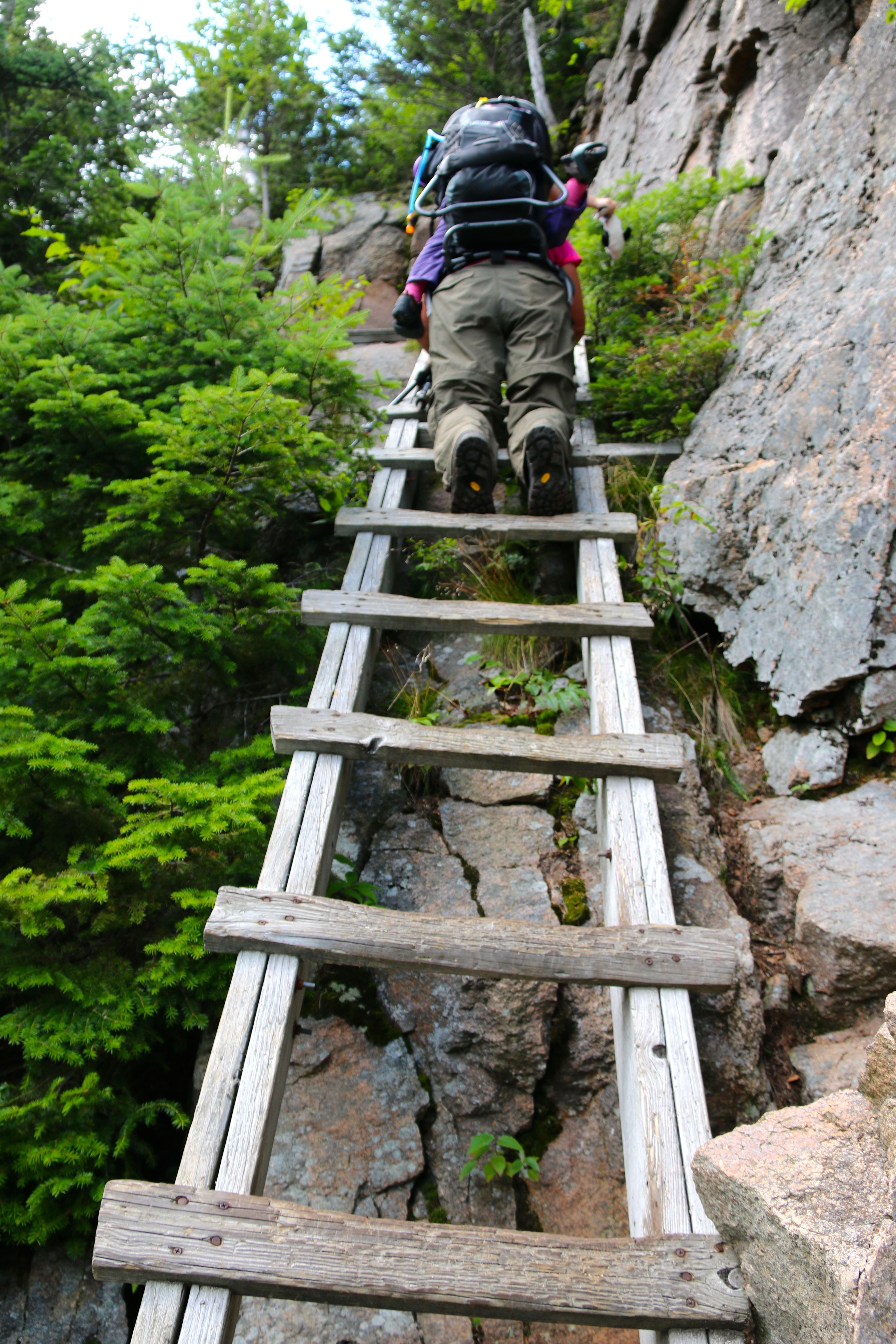
There are numerous trails up to Cannon Mountain. We took Hi-Cannon Trail. This is NOT a trail for those starting out nor a trail for the lone hiker with a toddler. This trail is tough and you will face many obstacles along the way including but not limited to stepping up on rocks, climbing over rock facings, climbing up rock facings, climbing rocks with views straight out and down and lastly a ladder. Yup, a ladder. To help you again, a l-a-d-d-e-r that is nailed to the rock facing. And the climbing is steep, some would say very steep and arduous.
The ladder part of the climb has two problematic areas. 1) You slip, you better recover really quickly. With a toddler on your back there is not room for error. So, take your time. 2) At the top of the climb, you do not have room to step up and off the ladder. You will need to step to left along a wood plank to step off the ladder then push yourself up to a standing position. You know, those ridiculous side squats or side lunges you either hate or ask yourself why someone is doing them. This would be where that training comes in pretty handy.
Climbing up the ladder…Almost to the top of the ladder
Looking down from the top of the ladder
After this stressful point of the climb, you will deal with more rock facings and more climbing. It is rather basic to what you just faced, but it can still cause some trouble especially if you are fatigued. The best thing about making it up this far are the views.
Of course, I just pointed to the lookout areas and J took the photos. This means my daredevil husband was hanging off a ledge to capture a few images.
Lonesome Lake from Hi-Cannon Trail
This is a panoramic photo that has been “stitched together” from multiple shots taken higher up from two different clearings.
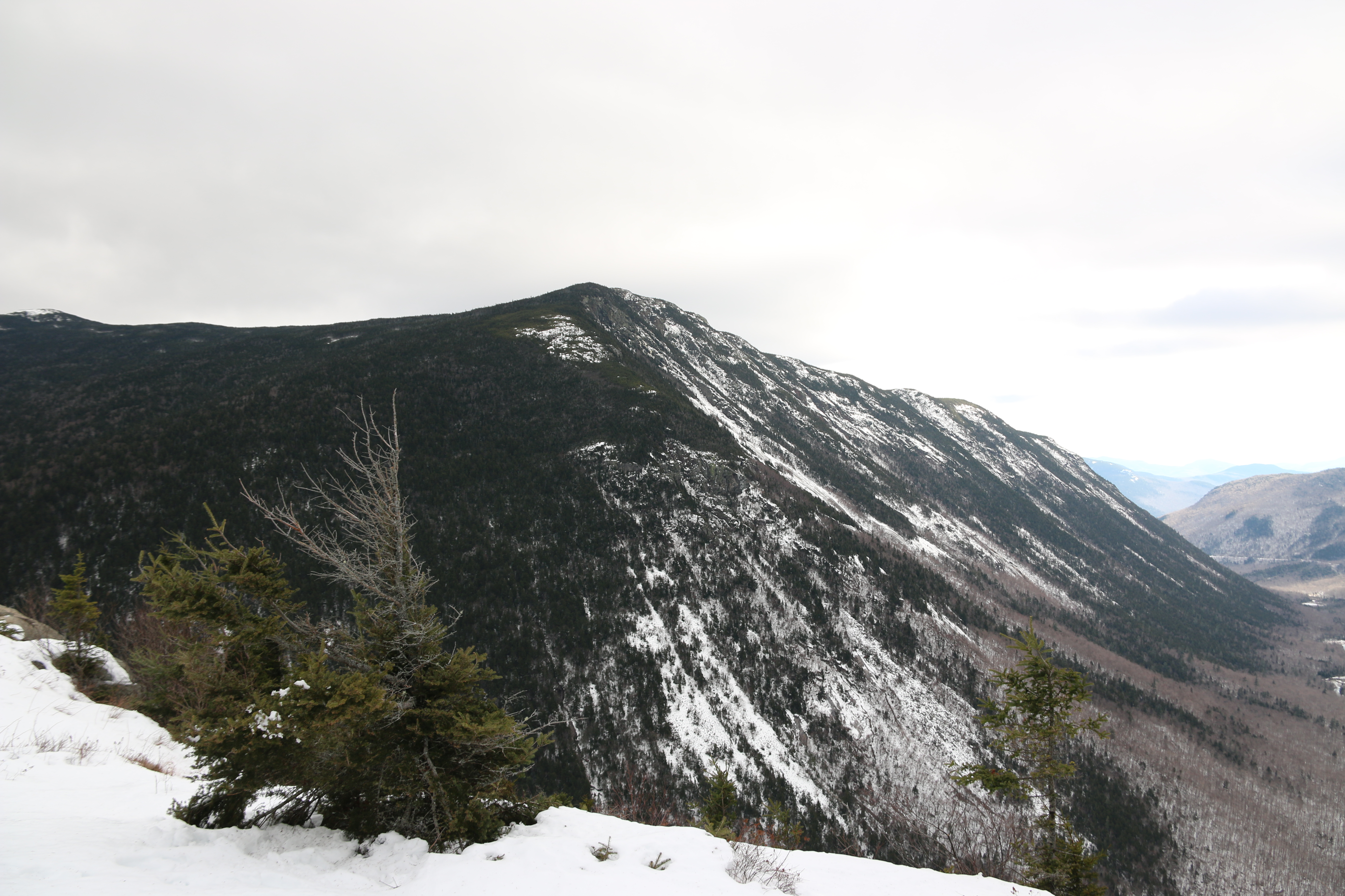
Panoramic View from a hanging cliff on Cannon Mountain to right is Lonesome Lake
After the ladder and the great views, you come to another junction, which is Kinsman Ridge Trail and Cannon Mt. Trail. This junction is the location where I suggest you rest and check your time. From here the summit of Cannon Mountain is a half mile. The views from the observation tower are amazing, but it is not worth putting yourself or hiking group in endanger due to weather or limited sunlight.
Your descent back to the hut will first be either Kinsman Trail Ridge or Hi-Cannon Trail are both challenging ascents and just as challenging if not more challenging descents because of fatigue. The Jimmy-Fishing trail is not as hard, but you will first have to make it to it.
With that said, J and I revisited our plan and pulled out the good ol’ map. We revisited our back-up plans and looked at all the trails down and decided the best route was for us to take the Tram down. Yeah, I know hiking up and not hiking down may not qualify as a true hike for some. But we made the best decision for us given the time and the fact that we hike with a toddler.
So, we hiked the half mile up to Cannon Mountain.
On the way to the summit
Ironically, we saw this sign posted. Be safe out there. Going up is only half the battle you still have to make it back down.
Hiker Code
We climbed up the tower enjoyed the view, captured the moment and thought about the hike up. All what we accomplished, as a team and as a family to get to enjoy the fantastic view in perfect weather.
A view from the tower
We climbed back down the stairs. J and I discussed how much we both reallyreally wanted to hike down, but we kept to our back-up plan. We knew it was best and safety thing to do.
The Tram is located about 500 ft from the tower. It costs 26.00 for our family and you pay it at the bottom. The Tram ride is under 10 minutes. At the bottom, there is a gift shop and locations to sit and enjoy some food and drinks. The views from the Tram are wonderful. We met some really wonderful people on the Tram and another group of hikers that made the same decision we did after their climb up Cannon via the Kinsman Ridge Trail.
Now, don’t get your panties in a twist, we still had to walk four miles along the bike trail and Pemi Trail to get back to our vehicle. That my friends is the hardest part four miles full gear and nothing exciting to climb or to distract you. Honestly, it is like walking full gear in formation in boot camp the only thing missing was the drill sergeant.
We did stop along the trail to see the ‘Old Man of the Mountain’ Memorial.
Daniel WebsterOld Man of the Mountain
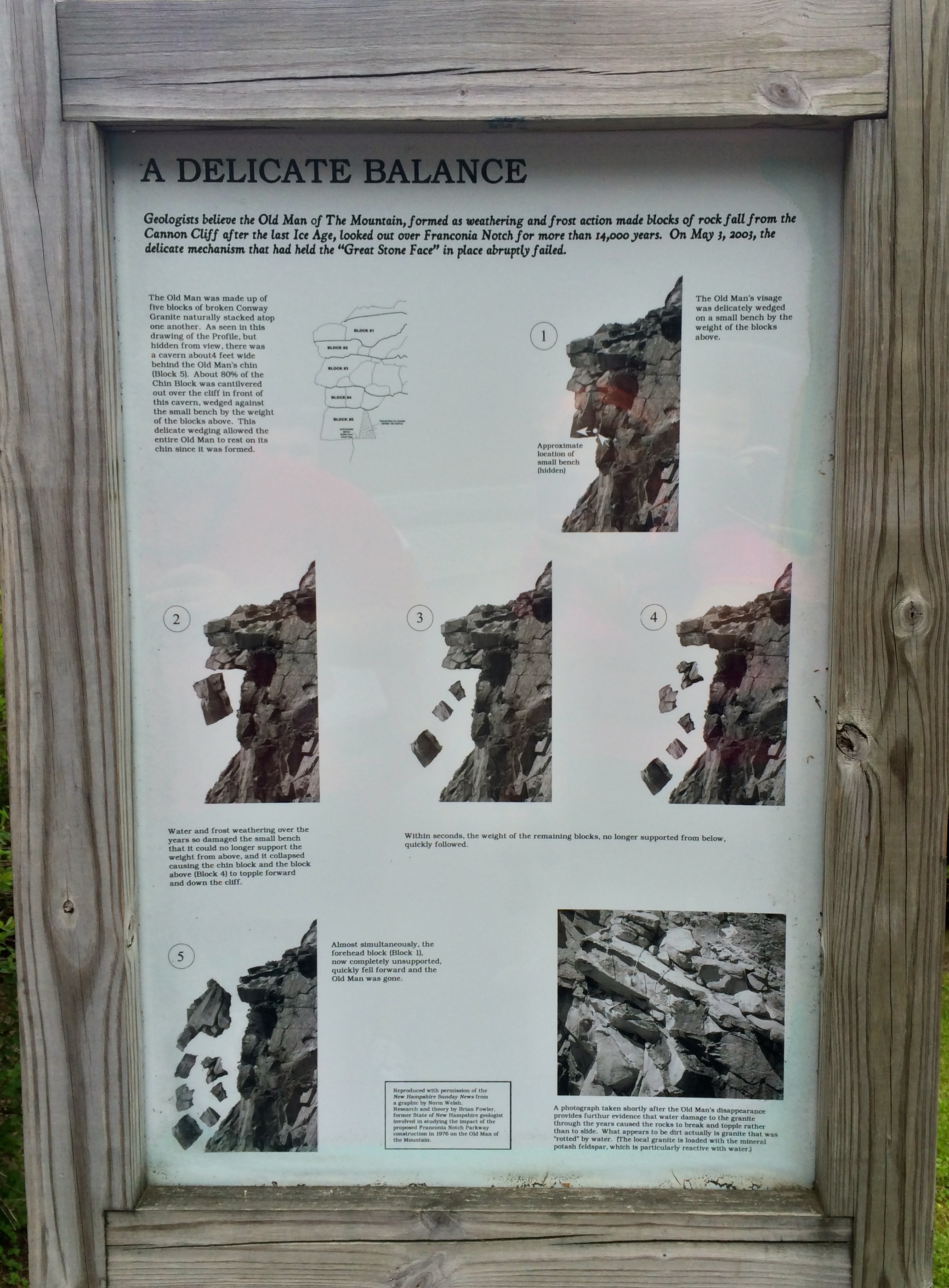
The fall of Old Man of the Mountain….
How Old Man of the Mountain fell
In all honesty, the walk back to the car is a pleasant walk. But I can say I was extremely happy to make it to the car. My Garmin Fenix clocked our hike as 13 miles with a moving time of 7 hours and 30 minutes. We got back to the car at 530PM with an hour and half drive back to our home. If we hiked down the mountain we were looking at arriving at the car between 730 and 8PM with the travel ride home. We definitely made the right decision for our family. I would say from how Miss M looked like she was ready for a dinner, bath and her bed.
I really wanted to label this post, “Traveling with the Three Stooges” or maybe even “Rocky & Bullwinkle”, but I will stay with tradition and keep it to the Mountains, Huts, and trails.
My reason for the “Three Stooges” is simple, we could not leave the house, nor start our hike without M’s companions. Their real names are Whale, Mr. G and Mickey. When you hike with a toddler there are days, they will need their own items and crew members. It’s small potatoes to us adults, but true deal breakers for them. To keep the loving terrible twos at bay and M happy, we brought them. So, I am thinking this is probably the first time in history a whale, giraffe and mouse climbed up to Mt. Hight, then to Carter Dome, to Carter Notch, to the Carter Notch Hut then back to the car to complete the loop.
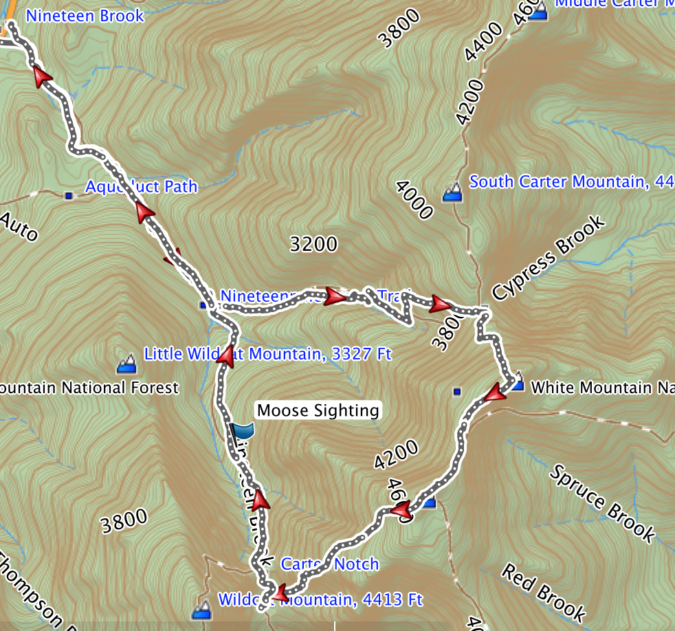
This is the second time we climbed this route. Our first time was last year, we ended up cutting the hike short and missing Mt. Hight. I am glad we did this since the weather was cooling and the daylight was falling.
We started at the Nineteen Brook Trail, located off Route 16. If you are coming from 302, Jackson, NH or Pinkham’s Notch, you will pass the Mount Washington Auto Road then travel roughly 5 to 6 miles. The trailhead is on the right side. Honestly, we hiked this last year with M, you can tell it’s the right parking lot because of the cars. It is definitely a popular place to hike. If you are unsure, look for this sign at the trailhead.
Trailhead Sign
We started this hike around 8:00/8:30 in the morning. If you are hiking in the Fall, I would consider starting a little earlier. The ending of sunlight might cause you to push through some great views. Also, without rest you may ended up hurting yourself. All the trails are marked well and well used. You will walk along the Nineteen Mile Brook for some time. Then you will cross over the brook before the trail splits.
Brook crossingMom and M crossing the nineteen mile brook
When you reach the trail junction, to head up to Mt. Hight (directly) you will go left and take the Carter Dome Trail. If you are hiking to Carter Notch Hut, you will continue on the 19 Mile Brook Trail. If you need to take a break, this is a good location to pull up a log or rock. It is a bit more roomy than anything you see face for roughly another two miles.
We went to the left and traveled up Carter Dome Trail for about 1.9 miles to another trail junction. The trail junction continues up to Mt. Hight and Carter Dome or you will take a ‘left’ to South Carter, Middle Carter, North Carter and Mt. Moriah.
This trail junction, this a great place for a break and many hikers use this location for just that. We met a two different groups of hikers here. Of course, they were thrilled and in awe to see us taking M up to the summit. This is where the game of “Whale” came about. Our little Miss M is a bit shy and tends to hide behind her stuffed animals and other items. With all the attention, she wasn’t sure what to do, so she created a way to say “hi” with Whale like she was waving, but every time anyone went to shake it or touch Whale, she would hide him. So, now this Whale game took place throughout the hike and carried into our next one. I am sure it will continue, since we cannot leave Whale at home.
After this break with a great group of hikers, we carried on up to Mt. Hight. You will travel along Carter-Dome Moriah Trail then take a left onto the Zeta Pass to climb up Mt. Hight. The first three-quarters to Mt. Height is pretty normal, but the last push to the summit is not for amateurs carrying a toddler or heavy weight. It requires climbing, some very large step ups onto rock facings, some balancing and without a doubt strong legs. I will say climbing up is safer than climbing down. You can continue on to Carter Dome then take the trail to Mt. Hight, if that works for you.
Mt. Hight was worth the climb and another good spot for rest. We did not take a rest there. We did snap some pictures then headed down to Carter Dome for lunch. Mt. Hight has some locations for children to walk around, but Carter Dome has a larger cleared area.
At the Summit of Mt. HightMt. Hight Summit, Mt. Washington in the background, Whale is on the attack with Mr. G (giraffe) readyMt. Washington from the summit of Mt. Hight
The descent from Mt. Hight to Carter Dome is easy and the walk over to Carter Dome summit is perfect after the climb up to Mt. Hight. Mostly, a straight wooded path.
Heading over to Carter Dome
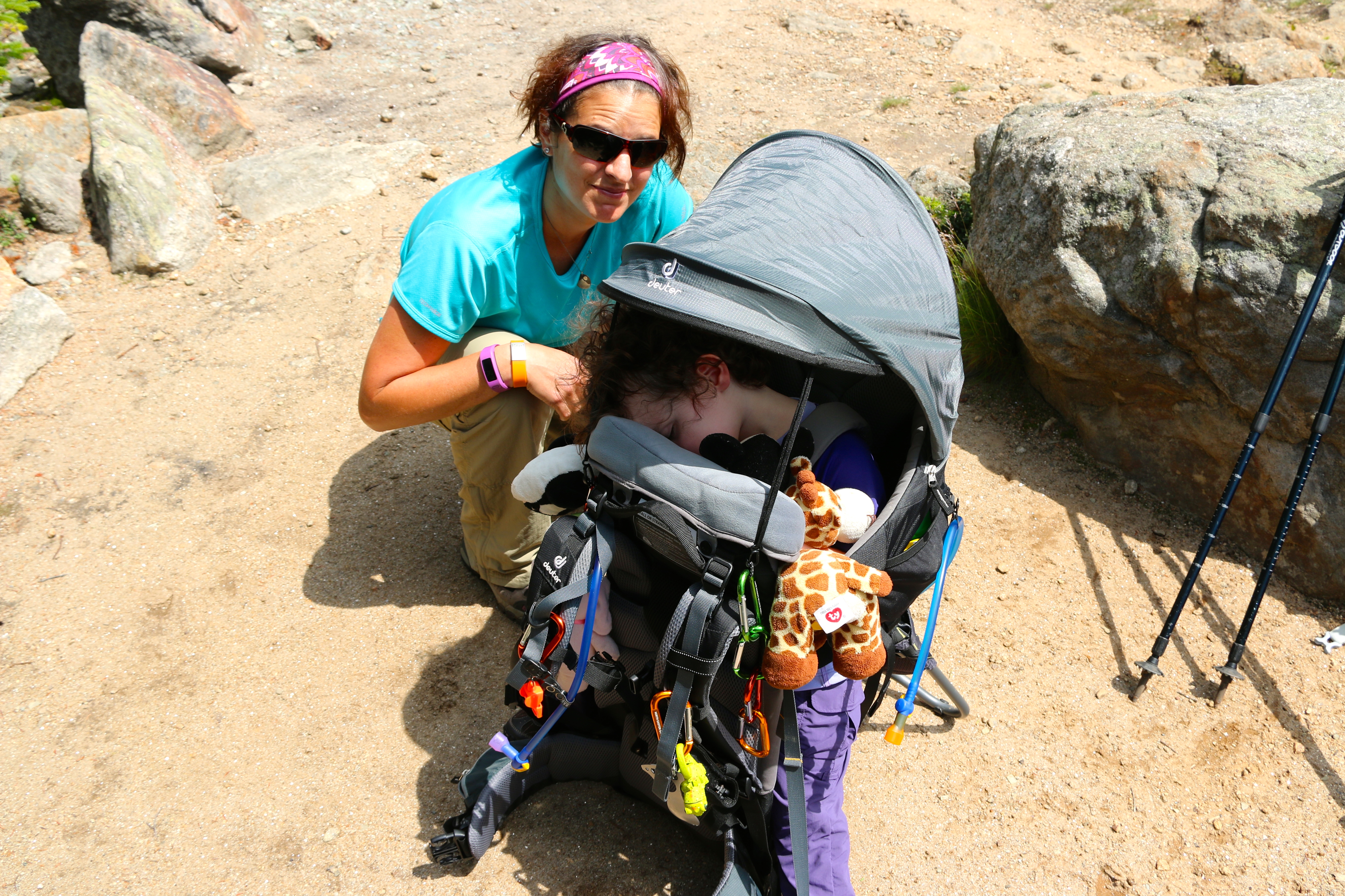
By the time, we reached Carter Dome, I heard something that sounded like a little snore with my mirror I saw M passed out. With care and help J, got me out of the carrier and M was still sleeping. In fact, she napped through our lunch break on Carter Dome.
Miss M napping, Love this pack!Miss M enjoying all the functions of the Deuter Kid Comfort III
We took about a 30 minute break here. We knew the climb down Carter Notch would be challenging. This is where your training really kicks in. Being fit is not about how much you can carry for a distance or how far you can go. Fitness is your rate of recovery. By the end of the lunch, I felt like I was just starting the day on fresh legs. Thank you off-season training.
M slept through getting back on my back and for her second summit picture of Carter Dome. This is where sleeping training for your child and helping them feel comfortable on a hike is worth its weight in gold.
Second Summit of Carter DomeFirst summit of Carter Dome
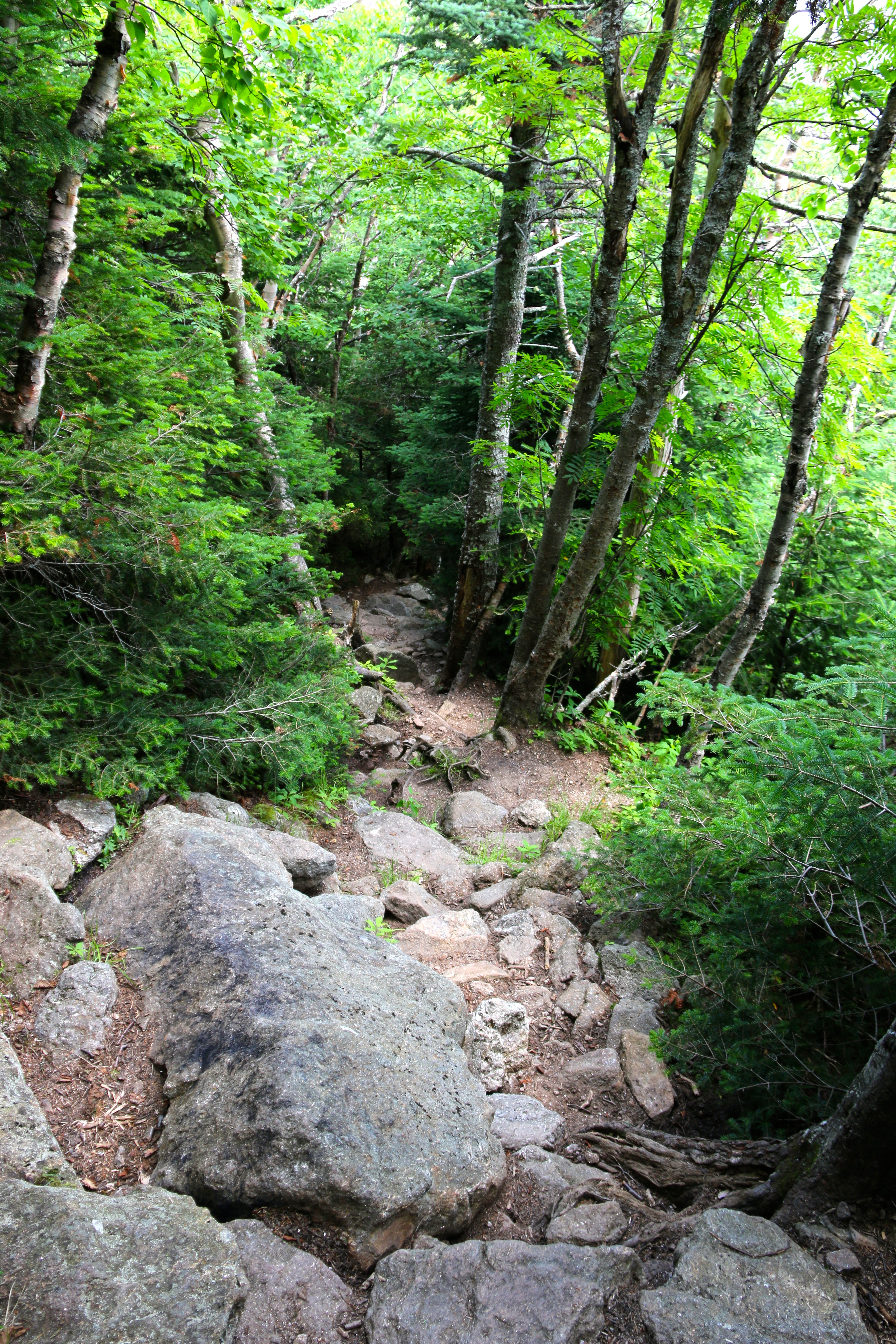
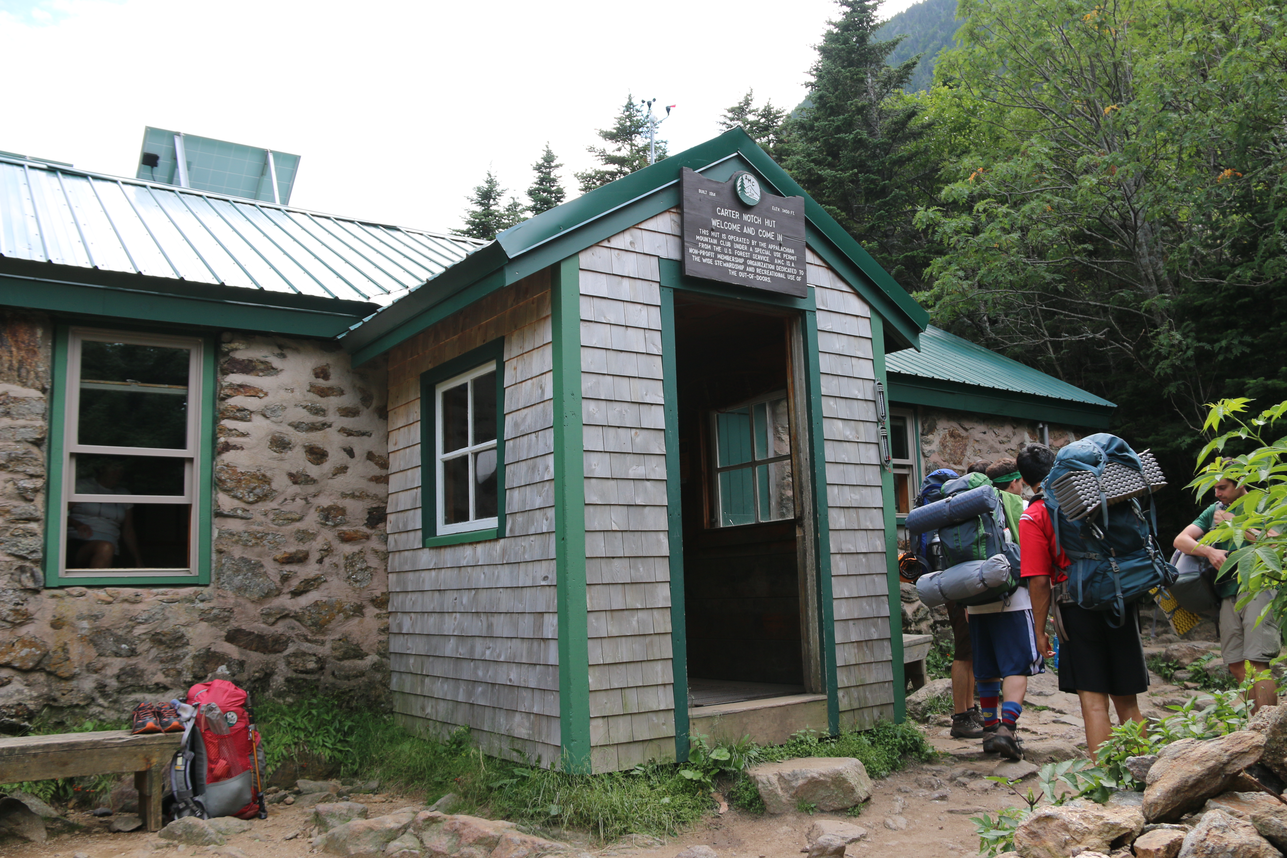
After the nice rest at Carter Dome, we headed down to Carter Notch making our way to our next break at the Carter Notch Hut. You will follow the Carter-Moriah Trail to the hut. The climb to the notch is a simple descent. At Carter Notch, you will be climbing down rocks almost to the hut. My free advice is to take your time. If you planned your trip well, took your breaks, this climb is nothing. If you are tired and hungry this can be tricky and lead to injury. There are some great areas to take some pictures and to look out.
Carter Notch
When you ask yourself, “Really, how much more of this before the hut?”. My answer is you are about half way there. Your climb down to Carter Notch Hut is absolutely worth it.
Carter Notch HutOn the Tranquil Mountain LakesTranquil Mountain Lakes from Carter Notch Hut
We had a lovely time at this hut. The crew at the hut was fanstatic. I suggest carrying some cash with you for some of their treats and meals. Our first step into the hut was like stepping into grandma’s house. They were cooking chili for dinner, had brownies and lemonade. My mouth still waters thinking of the smell. Miss M was up by the time we hit the hut and ready to eat anything and everything insight.
She enjoyed her sandwich while she talked and entertained the crew and two hikers we met way back at the trail junction at Carter-Moriah and Zeta Pass.
Miss M eating her sandwich at Carter Notch Hut
The Carter Notch Hut is a perfect place for overnight stays, water refills, bathrooms, food and rest. The above pictures should help you grasp the beauty. You probably want to book ahead for a stay and dinner or you may find yourself without a bed and seat. This link, here, should help you.
After our visit at the hut, we carried on back to Route 16 via Nineteen Brook Trail. After, Carter Notch descent the rest of the hike is pretty easy. The only thing you will may face is your mind kicking in asking when you will be done. Well, you have over 3 miles to go. So, use your break wisely.
On our descent, I needed some time to reset my mind, so I played some low volume music for myself and J. Well, after 3 songs, “Days Go By” by Dirty Vegas came on. I had the iPhone player set to random, I have over 2k songs loaded. I have a membership through MegaBoon.com, 10 cents a song. It beats iTunes, if you aren’t in a rush for the song. Anyhow… the proceeding conversation took place…
“Days Go By” by Dirty Vegas comes on …
J: Hey, do you think there is a Moose out there bee boopin to this song? You know, eating it’s dinner and dancing?
Me: Yeah, I am sure. And there is a Squirrel right next to it enjoying a nut.
J: Oh really, you watched “Rocky & BullWinkle”????
Me: Yes, re-runs…
J: I wonder if M would like it.
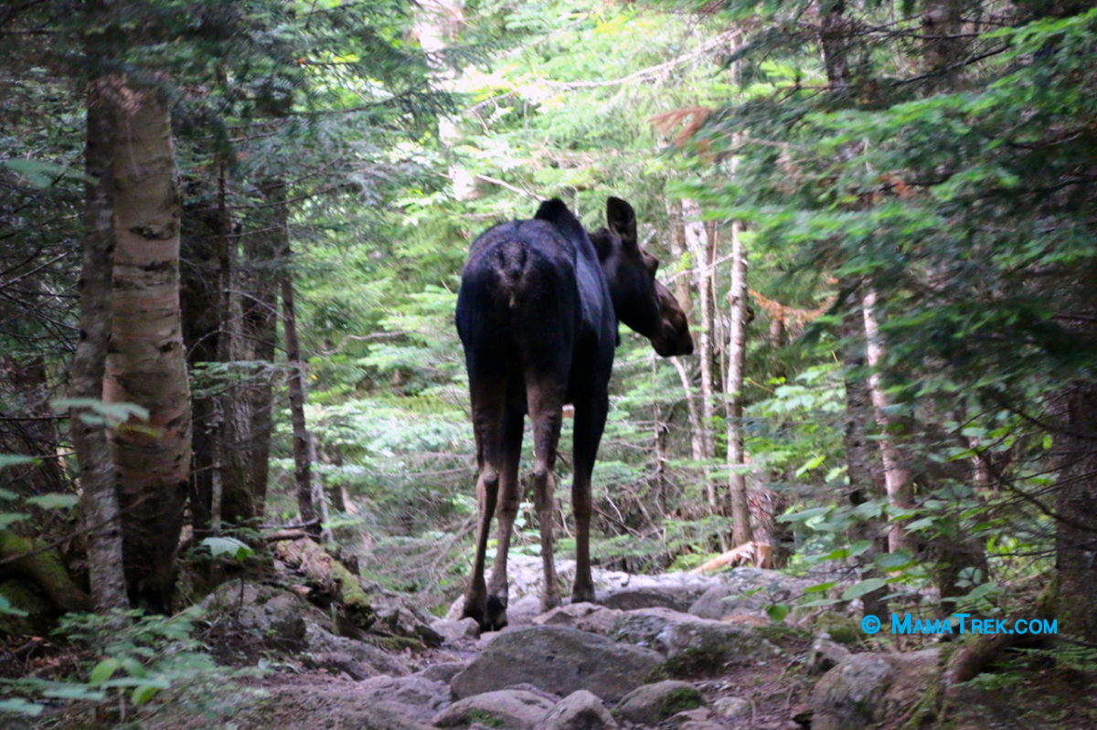
A few minutes pass on the trail then I get the hand signal to turn everything off, quiet Miss M and stay put. I am thinking is crap we crossed paths with a momma bear and cubs. But no, this beautiful animal walked right on the trail like she heard our conversation.
Cow on the trail
Well, we had nothing to do but play “follower the leader”. She led the way for about a half mile then went into the forest to the right. Not far off the trail, we heard her walking and then eating. What an incredible sound. We hung out for a bit. We didn’t know if she had any family in the area. But in about 4 minutes, she walked back on the trail and lead the way for another quarter-mile before turning off into the woods.
I got nothing. I am Irish, but this luck is purely beyond that. I am amazed but the cow’s actions and honored that she stepped out on the trail. We let every hiker we knew traveling up the 19 Brook Trail to be alert for a moose. We are not sure, she crossed paths with them or not.
After another quarter-mile, we crossed paths with a squirrel in the middle of the trail. Yup, you got it, sitting there eating a nut.
Rocky eating its acorn, in the middle of 19 Mile Brook Trail
I got nothing, again. But I do know J cannot say he never saw a moose or a squirrel eating an acorn.
But, in all seriousness, when you hike down from Carter Notch Hut is basic and very pretty. This trail will lead to back to the first bridge crossing. The location of my first suggestion for a break.
If you hike the trail in the latter afternoon, I suggest keeping an eye out for whatever wildlife that may cross your path. I never would have thought a Cow would just walk out of the woods and hang out like she did.


